Berkeley Pit

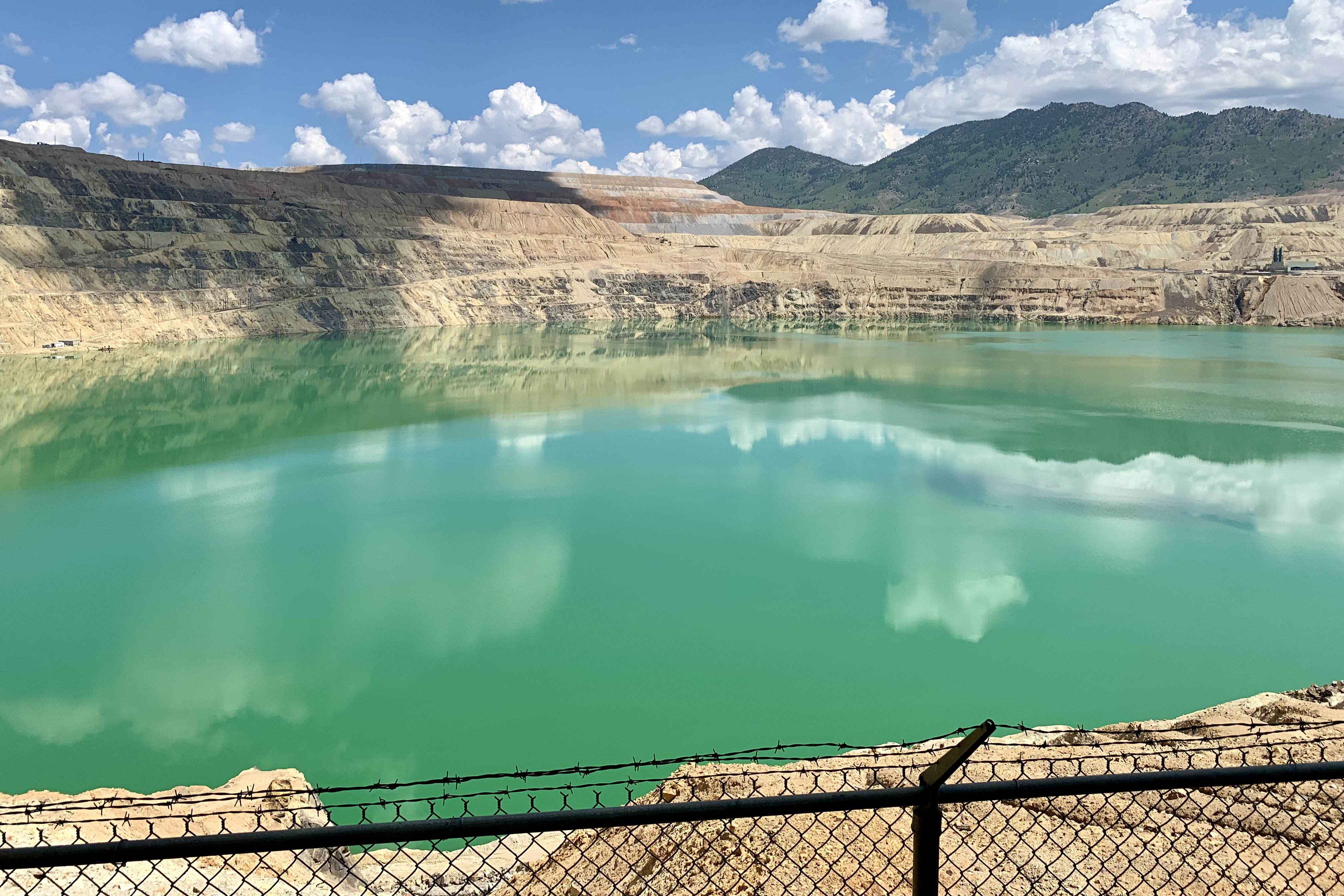
Located in Butte, a former open-pit copper mine, closed in 1982. The pit is laden with heavy metals and dangerous chemicals. It is one of the largest Superfund sites.

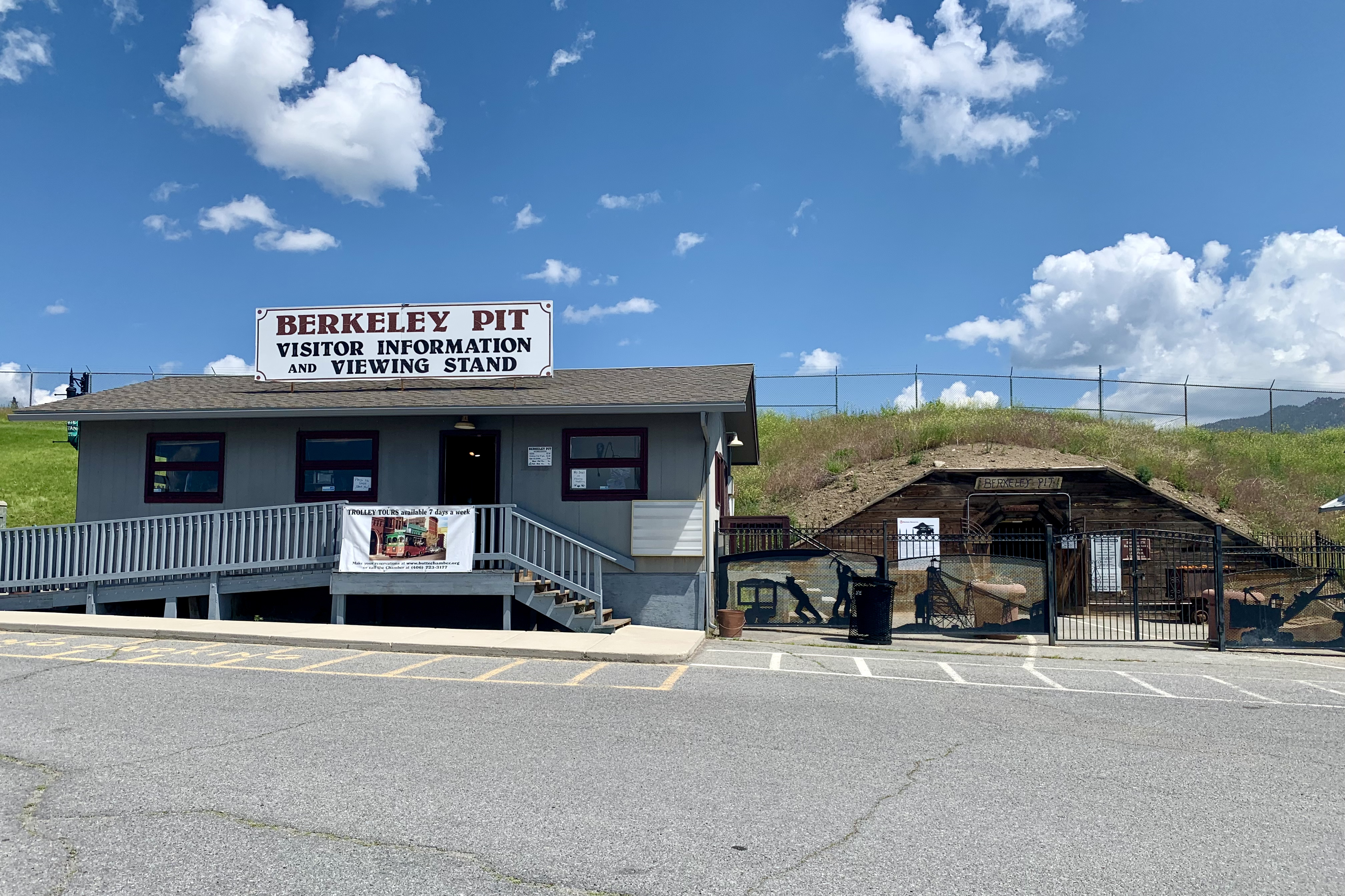
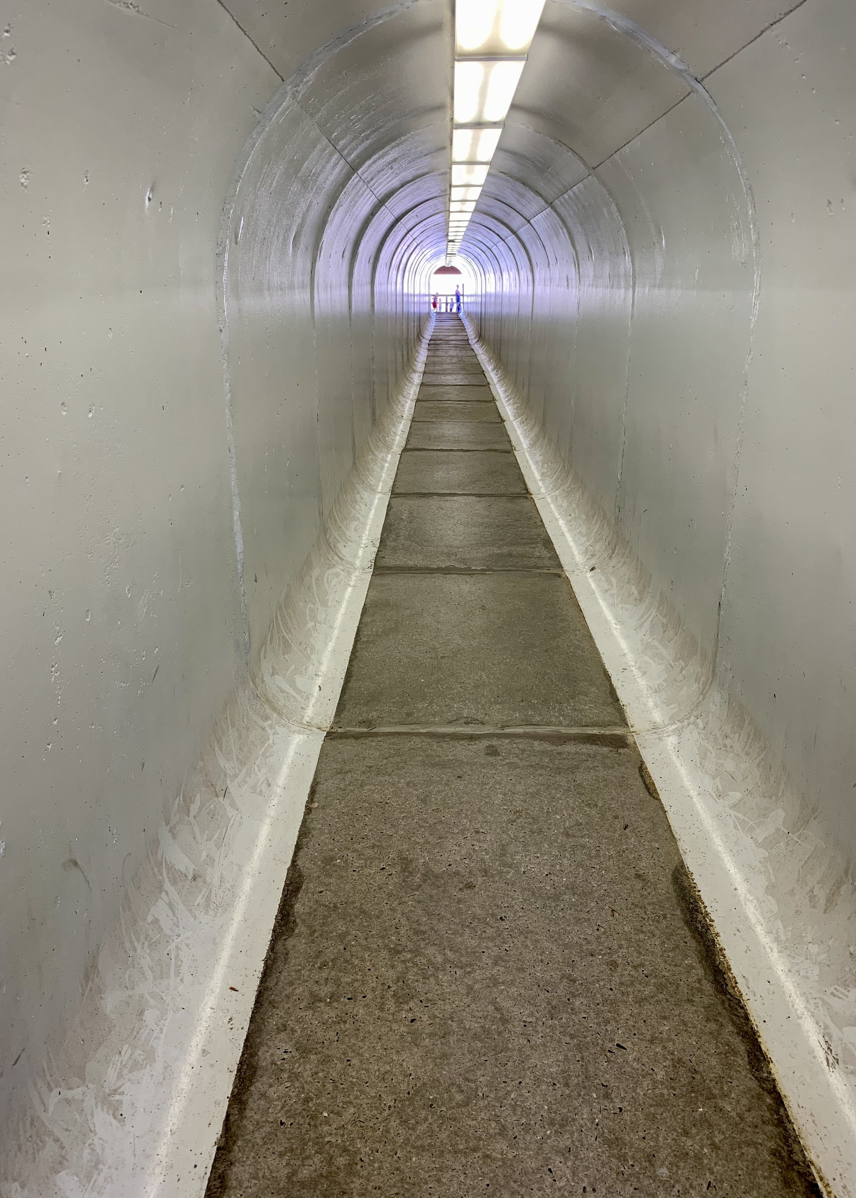
After you pay a modest admission, you exit the side door and enter what looks like a mine entrance and then a long tunnel.

One mile long, a half mile wide, 1780 feet deep, filled with heavily acidic water to a depth of 900 feet. Too many birds have died here. A type of sonic bird scarer goes off periodically to keep birds from hanging around.

Bozeman bike trails = 6

The first five trails were connected to each other. Oak Street Trail = 1.9 miles along a busy traffic corridor with many business driveways to cross.

N 19th Avenue Trail = 0.5 miles, another busy traffic corridor. Abrupt end.

Front Street Connector = 0.3 miles, too short for a picture. Story Mill Spur = 1.7 miles.

In a distant field, a huge bird with butterfly wings.

Bozeman to Bridger Mountains Trail = 2.1 miles.

I’m not sure how far I got, but the trail began to narrow and big rocks showed up. Turn around point:

I took a bike route to the start of the next trail. To the left of the building is a beautiful start to the Gallagator Trail = 1.6 miles.

Sculpture park.

Although partly a packed dirt trail, this was my favorite. The southern trailhead, near the Museum of the Rockies.

All those trails, out and back, one return trip to the hotel in the middle of the ride, and I rode a total of 16 miles. Note to self: don’t ride off with the car keys in your pocket if someone (Phyl) is supposed to pick you up at the end of the ride.

Museum of the Rockies

Phyl and I drove to Bozeman, known up here as the Los Angeles of Montana. Apparently a lot of people from S California relocated here or have second homes. In the afternoon we went to the Museum of the Rockies.

This guy looked up occasionally to see if anyone wanted to talk:

On one side:

On the other side:

There was also a great Da Vinci exhibit with 60 fully built, life-size inventions,

many of which said “Please touch.”

Outside, there was a living farm. In the kitchen, volunteers in costume were making chokecherry syrup.

Deer Lodge Art Club

Across the street from the Old Montana State Prison,

is the Deer Lodge Art Club.

Dave joined the art club. Today was his day to volunteer. The gallery currently has a showing of wood block prints by Frederick Remington. This one was titled “Thanksgiving Dinner.”

In the back is an artists studio where classes are held or community projects are restored.

Dave and Phyl’s

I will be here for about a week. Dave’s skills are greatly appreciated:

The view from across the street. Part of the Grant Kohrs Ranch National Historic Site.

Old US10, the view to the north:

To the south, in 1 mile, you reach the outskirts of downtown Deer Lodge. Population 2935 in 2021.

Arrow Stone Park Trail

When I looked up trails near here, the first trail that popped up was the Great American Rail-Trail. The preferred route of the Great American Rail-Trail connects 145+ existing rail-trails, greenways and other multiuse paths spanning more than 3,700 miles across the USA from coast to coast. And this 1.6-mile section in Deer Lodge is part of that system.

In the background, the Old Montana State Prison. This was a fast photo stop! Mosquitos descended on me.

The southern trailhead.

Suggestion: when the next a bridge is built, lay the planks perpendicular to the path of a bicycle tire. Riding on parallel cracks or grooves is destabilizing for some cyclists.

The northern trailhead. The Old Montana State Prison.

I rode the trail several times, then rode around the downtown area and eventually ended up riding 11 miles.

Wood River Trail

I stayed in Bellevue at the southern end of Sun Valley. The trail was just across the street.

I rode north toward Ketchum, slightly uphill all the way.

Spur is the name of the sculpture created in 2016 by John Grade. It was inspired by Grade’s visit to Craters of the Moon where he digitally mapped the inside of a lava tube.

It’s motivating to ride to a delicious place to have a coffee and cinnamon roll before heading back.

The ride back was fast, downhill with a slight tailwind. 37 wonderful miles.

The drive to Sun Valley

A short drive today! Once I turned east and began climbing, the scenery was beautiful. A couple of scenic viewpoints. The road I just traveled:

On the other side of the road after the 5527-foot summit:

I stayed in Bellevue, south of the main touristy area of Ketchum and Sun Valley (the town). Nice hotel, friendly staff,

and a free ice cream from the cutest trailer in their parking lot.

Boise River Greenbelt

I choose hotels that are close to the trail I want to ride the next morning. Just one intersection to navigate to get to a safe bike path along a really busy road then

down a ramp to the Boise River Greenbelt.

When the “natural path” began, it was time to find the paved trail:

Thank you, Ada County, that 1.6 miles stretch is really bumpy.

A deaf bike rider and I ended up at this spot at the same time. Pretty soon, we were making gestures to each other that these guys are crazy and riding bikes is much better. To get in position to “ride the wave,” you could swim upstream to a ledge or scramble onto the rocks and walk upstream, paddle over and carefully go over the edge and set up. The guy in the red sweatshirt was two-footed jumping from rock to rock.

The northwest section bordered Boise State University:

Great trails, lots of connections on both sides of the river. The trails extend beyond the Greenbelt going all the way to Eagle and south as well. I would ride here again. 31 miles.